The Columbia River draws a mighty pen stroke as it curves and weaves its way to the Pacific Ocean on North America’s map. Many tributaries, like the Kootenay River, join it along the way. These rivers not only nourish the land but also shape the lives of those who inhabit their shores, from fish in the depths to wildlife along the banks to communities that rely on its water and power.
Spanning 2,000 kilometres from its source in Canal Flats, British Columbia, to its mouth near Astoria, Oregon with a watershed larger than the country of France, the Columbia River defines the geographic, economic and political landscape of this region. It’s also a major artery, connecting ecosystems from B.C. to Washington, Oregon, Idaho and Montana.
Wildsight’s vision is to see the Columbia River watershed recover some of the natural abundance that was present before the construction of dams. Dams in the Columbia Basin have provided many benefits over recent decades and will play an important role in the decarbonized energy systems of the future. However, they were built with almost complete disregard for the rich plant, animal, and human communities designed around the rhythms of free-flowing water. In many cases, the way the dams are operated still ignores ecosystem health, Indigenous voices, and riverside communities. We won’t be able to recover everything that was lost. But we can work together to find better balance.
An ecosystem under strain
Over the course of the last century, humans have applied engineering and a narrow focus on short-term economic interests to transform the Columbia River from a complex natural system into a machine — or as close as to a machine as possible. Today, there are 14 dams on the main stem of the Columbia River and dozens more on its tributaries.
The large storage dams built in Canada were among the most destructive with huge reservoirs silencing some of our richest valley bottom habitat. For millennia, millions of ocean-going salmon migrated up and down the river enriching land and people alike. With the dams, salmon have been blocked from most of the upper watershed for more than 80 years, although Indigenous Nations and Tribes are working hard to bring them home. Climate change threatens to deepen this historic damage with uncertainty and increasingly extreme conditions.

Politics of water
Shared exploitation, shared stewardship:
While the Columbia begins its journey in Canada, it has long been viewed as a shared resource between the two nations, affirmed in law with the landmark U.S.-Canada Columbia River Treaty of 1964. Reflecting the dominant values of its time, the treaty’s only purpose is to use dams to enable development on downstream flood plains and maximize the generation of hydropower. The treaty entirely ignores the environment and excludes Indigenous Nations and Tribes and riverside communities. The treaty profoundly shapes the modern-day flow and use of the Columbia, as well as the Kootenay River, which crosses the border twice on its way to join the Columbia.
A common story told about the treaty is that it reduced flooding across the Columbia River Basin, but that’s not the whole truth. In reality, the treaty traded natural springtime flooding of seasonal wetlands along the lower river near Portland for unnatural floods filling more than 600 kilometres of valleys in B.C.’s Kootenay region. This has enabled the U.S. to build infrastructure in historic floodplains.
To make this possible, the Columbia River Treaty dams in B.C. flooded an area roughly three times the size of Kootenay Lake (approx. 110,000 hectares), destroying ecosystems and displacing thousands of human residents while inundating Indigenous cultural sites and productive agricultural lands. In a typical year, water levels behind these dams are toggled between very low to very high to serve downstream interests. These drastic fluctuations do not allow for vegetation along reservoir shorelines or high quality habitat for fish in streams flowing into the reservoirs. They have detrimental impacts to recreation and tourism as well as industrial barging and log towing.
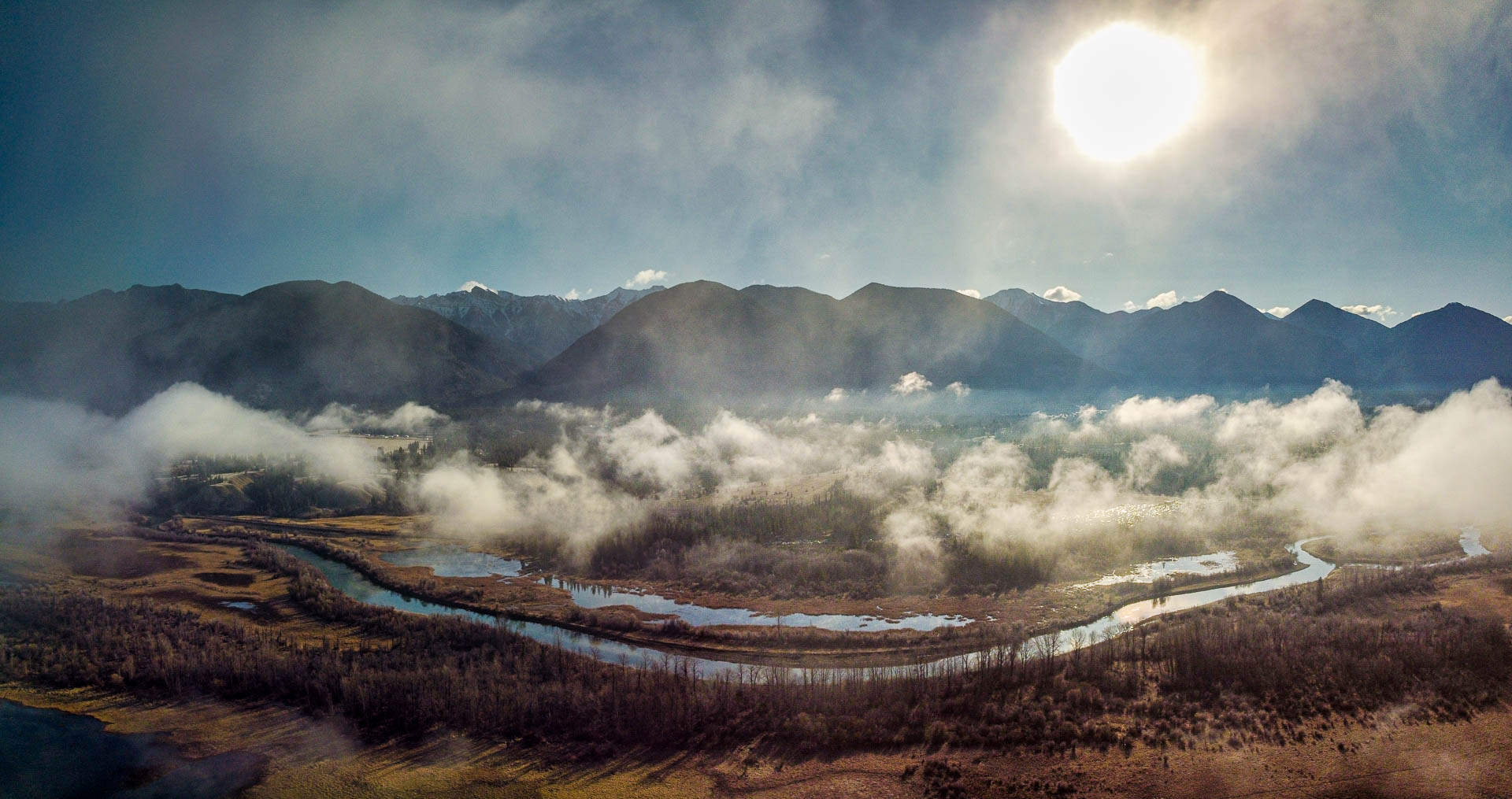
Today, the only fully free-flowing portion of the entire river is the Columbia Wetlands between the headwaters in Canal Flats and the start of the Kinbasket Reservoir near Golden. This incredible remnant is the largest intact wetland left in North America, at 180 km long.
For more than sixty years, the treaty has driven both economic and environmental decisions on both sides of the border. Historically, the river’s health and the voices of Indigenous people and local communities have been ignored.

Key moments in the treaty
- 1940s and 1950s: As development pushes into historic floodplains and demand for power grows, officials in both countries become increasingly interested in controlling the river’s flow
- 1964: Columbia River Treaty is ratified with no consultation of Columbia Basin residents or Indigenous Nations
- 1964-1975: Construction of Hugh Keenleyside, Duncan, Mica, and Libby Dams. Valleys are flooded with massive wildlife losses and thousands of people forcibly removed from their homes.
- 1990s: Criticism mounts over historic injustices and ongoing impacts from the annual raising and lowering of reservoirs to fulfill treaty obligations to the U.S.
- 1995: Columbia Basin Trust is formed in recognition that residents weren’t adequately consulted on the treaty and disproportionately bore the burden of its negative impacts
- 2011: The Columbia River Treaty Local Governments Committee is formed to help Basin residents and local governments engage in decisions around the future of the Columbia River Treaty
- 2016: Wildsight and other environmental organizations begin working together on the treaty as the Upper Columbia Basin Environmental Collaborative
- 2018: With some portions of the 1964 treaty set to expire in 2024, Canada and the United States begin formal negotiations to ‘modernize’ the agreement
- 2019: Indigenous Nations officially join the Canadian negotiating team to work alongside provincial and federal governments — a first in Canadian international relations
- July 2024: Negotiators reach an Agreement-In-Principle
- December 2024: Canada and the U.S. enter into ‘interim’ agreements to bridge the gap between the Agreement-In-Principle and a full modernized treaty
What’s next?
With unprecedented political uncertainty, the path to completing the modernized Columbia River Treaty is unclear. Wildsight and partners are supporting efforts to finalize the July 2024 Agreement-In-Principle as soon as possible. Stay tuned for updates.

Wildsight at work
Wildsight is engaged in ongoing discussions as well as education around the treaty and watershed management.
- Upper Columbia Basin Environmental Collaborative (UCBEC): Working with local, regional, and provincial partners, we are actively engaging in the modernization of the Columbia River Treaty.
- We have published detailed technical commentary on the treaty. Most recently, our review of the Agreement-In-Principle with recommendations for improvement.
- UCBEC’s technical representative participates in ecosystem research led by Indigenous Nations that has directly informed Canada’s treaty negotiating team.
- Current members include Wildsight Regional, Wildsight Revelstoke, Living Lakes Canada, Friends of Kootenay Lake Stewardship Society, Yellowstone to Yukon Conservation Initiative, and BC Nature. Fifteen additional organizations in the Canadian Columbia Basin have also pledged their support for our objectives.
- Supporting Indigenous-led salmon reintroduction: We amplify Indigenous Nations’ calls for resources and support to help this groundbreaking work continue.
- Columbia River Conversations: Fostering dialogue and place-based connection between community leaders, youth and other stakeholders in the Columbia River watershed.
- Columbia River Field School: Inspiring youth to understand and protect the river by bringing the classroom out onto the water.
- Teach the Columbia: Curriculum for teachers to bring watershed education into the classroom
- Columbia wetlands focus: Wildsight has advocated for this particular stretch of the river between Canal Flats and the Kinbasket Reservoir since we were founded in the 1980’s. From demands for better protections for wildlife, to gaining international Ramsar wetland designation and banning power-driven boats from the wetlands, we are committed to safeguarding this remnant of what the Columbia River once was.
- Upper Columbia Swallow Habitat Enhancement Project: The Columbia Valley and the prominent Columbia wetlands contain important habitat for swallows and other birds. Through multi-year inventorying, monitoring and projects, Wildsight is working to restore swallow populations in the region.
How you can help

COLUMBIA RIVER TREATY
Learn more about the Columbia River Treaty process and stay tuned for opportunities to participate


explore the water
Get to know the waterways in your backyard and consider how they connect into the larger Columbia River watershed.

Give a gift for the wATER
Make a difference: Donate to support Wildsight’s continued work in protecting the Columbia River watershed